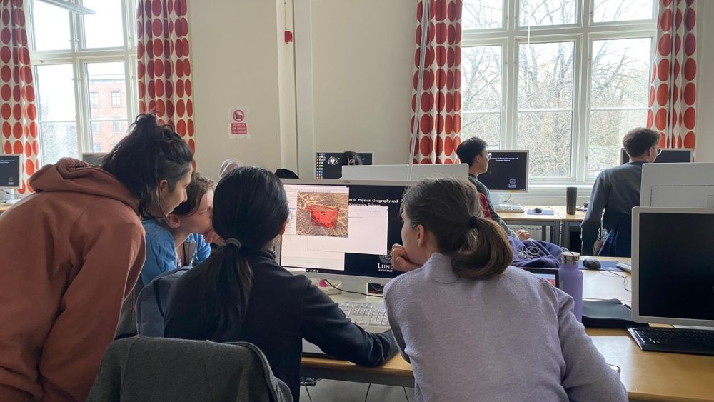
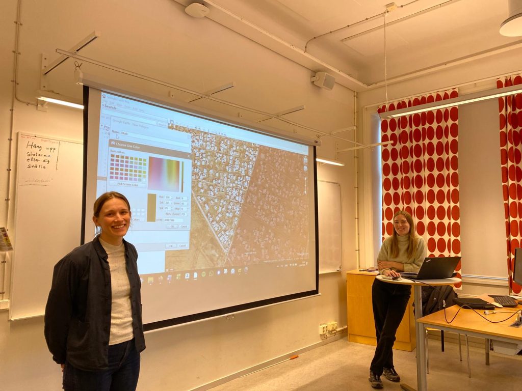
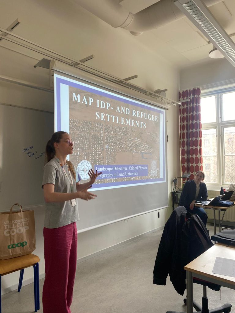
To contribute to this work, we, in collaboration with the Southern Swedish Geographical Society, organized another mapathon! This time, we focused on settlements for displaced people in Iraq and Jordan. Using satellite imagery and Google Earth Pro, participants mapped settlement boundaries and digitized structures within camps. Beyond identifying camp extents and buildings, the mapping also aimed to better understand the internal spatial organization of the settlements and how these environments change over time. This kind of information can help us identify climate-related risks inside camps and explore suitable adaptations. For example, open spaces within camps could potentially be used for vegetation or low-growing agricultural plants, reducing flood risks and increasing food security. Smaller spaces between structures may also be suitable for tree planting, which can give shade during extreme heat, improve local food security, and help absorb excess water during heavy rainfall events.
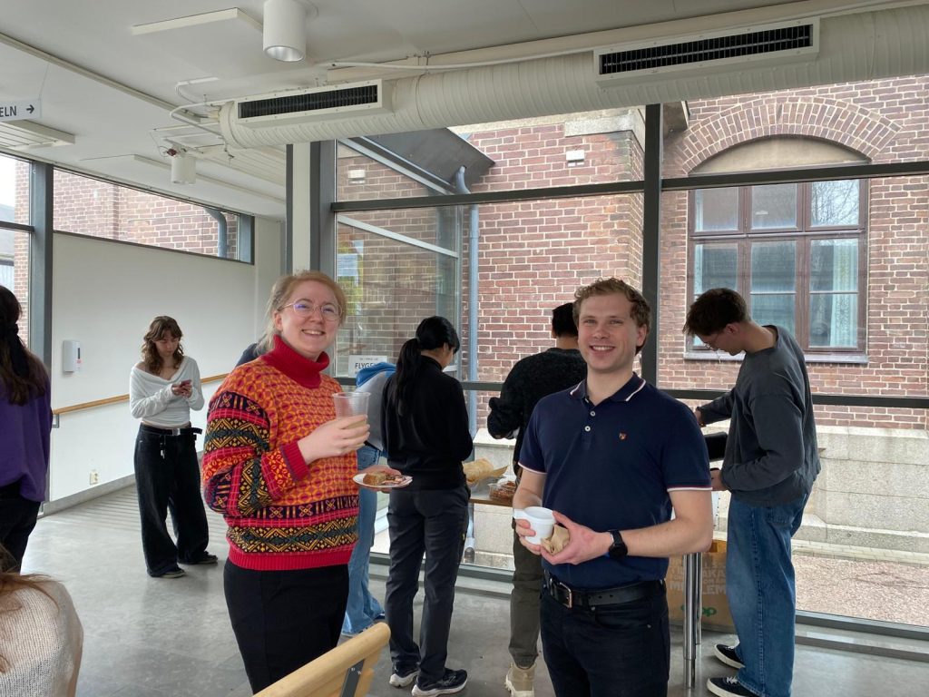
The research related to this event is a part of the project Climate risk and adaptation in the Middle East. We hope that the generated data may support fieldwork, further exposing environmental risks and the potential for adaptation in settlements for displaced people. Finally, we are grateful for the contributions of all participants and happy that so many show an interest in such an important topic!
During the Cold War, the US used imagery intelligence (such as satellite images) to collect information on Soviet weapons of mass destruction (Pringle & Ranson, 2025). This method continued to be used by governments and security forces, and are today open for many more to use. Free versions of satellite data and digital resources can be found on a wide array of platforms, along with videos teaching the public how to use them. Open source information, that is publicly available information that any member of the public can observe, purchase or request without requiring special legal status or unauthorized access (United Nations & University of California, Berkeley, 2022), has become a given in today’s digital world. This has brought about the term open source investigations, which refers to utilizing information from publicly available sources to address specific issues or questions. It exists in many forms, such as open source journalism, and a variety of “intelligences”. Among them are OSINT (Open Source Intelligence), GEOINT (Geospatial Intelligence), IMINT (Imagery Intelligence), SIGINT (Signal Intelligence: radio signal, etc.), and HUMINT (Human Intelligence: interviews, eyewitnesses, etc.). Open source investigations are used on a global scale to investigate anything from news, social media, and statements from public officials, to human rights violations, war crimes, and wildfires.
There are of course many more examples, not only from journalists, researchers and NGOs (Nongovernmental Organizations). Military personnel, stalkers, human rights advocates, bored teenagers, law enforcement, terrorists, influencers – they can all use it. Anyone can be a fact-finder.
Or… Can they?
Access, ability and ethics
In reality, it is not always as easy as “anyone” can be a fact-finder, because although data and information might be free, most other things are not. In reality, anyone with access to internet, electricity, a computer or smartphone – and the knowledge and ability to use it – can be a fact-finder. Those with good eyes for details, local knowledge and the ability to speak multiple languages also gain some advantages, as those who are visually impaired, or lack local knowledge (or the understanding of certain languages) might completely miss important details in the midst of all the web’s available information.
This relatively wide availability also brings about the Dual-Use-Dilemma: If something is useful for unethical purposes, does it justify not producing it to be used for ethically sound purposes? Are the rewards worth the risks? This dilemma refers to situations where information, tools, or technologies developed for legitimate or beneficial purposes can be used for harmful or malicious purposes as well. Satellite data can for example be used for research, prosecution of human rights violations, or finding your way to a new location. But it can also be used for locating military targets, stalking people, and spreading false information to the untrained public.
Data collection
Everyone with access to a camera and internet, can also contribute to the collection of data, although they might not be a part of the analysis of it. Violence, crime and a variety of violations are uploaded to social media continuously. Well-known examples are those of terror groups like ISIL (Islamic State of Iraq and the Levant), which film and post executions. From these visuals, authorities were able to identify perpetrators, and later convict a Swedish man of war crimes in Syria. Such evidence is abundant in many of today’s conflicts, but are unfortunately also often deleted from social media by the Big Tech owning the platforms. As these videos and photos often include graphic content, they are removed from many platforms, even before other users have seen them. This might be good in the aspects of protecting the anonymity of the victims, but it also removes evidence that can be used against the perpetrators. Each platform has their own reasoning in their user guidelines, but it is often mentioned as an act to “inhibit the glorification of violence”, or to “protect the platforms users”.
Available tools
There is a vista of tools and resources available for open source investigations, some a simple as a reverse image search. Visual search engines can be used to find the original source of an image, which can add context to it. This can help indicate if an image is a photograph, a generation, or an alternation. It can also tell us where it was taken, by whom and when. It is of course important to remember that images are only visualizations of something, and not necessarily the absolute truth.
Keeping an eye out for spatial or temporal information in images or text can also help indicate suspicious information. Platforms like suncalc.org can help us question the time of day or year a photo was taken, which in turn can be used to question the reliability of the image, post or article in question. The image can be real, displaying an event that actually happened, but the text combined with it may be false, or true for an unrelated event. Shadows can tell us if an image was taken at the time, and sometimes place, stated in the text.
Platforms payed for by the taxpayers can sometimes hold vast amounts of free data. Examples of such are the European Space agency (ESA) and Copernicus data portal. The Copernicus browser is a user-friendly option for accessing a variety of satellite imagery (global, although focuses on land areas). FIRMS is another example, managed by NASA (National Aeronautics and Space Administration), which can be used to locate fires around the world. It is however biased towards large fires, as small fires can be difficult to register by satellites. Not managed by governmental agencies, but another good option for easily accessing satellite imagery through time is Google Earth.
For tracking aerial or marine vessels, FlightAware, FlightRadar24 and VesselFinder are good options, although going far back in time might be problematic. The WayBackMachine is however great at going back in time, especially when looking for previously available – now deleted – information. There are of course also websites focusing specifically on collecting available resources and data, such as UNISHKA.
Shape the story
Open source investigations are powerful when combating crime, but for most people, their value lies in everyday use: questioning and critically engaging with social- and news media. In a world where information is abundant, the real challenge is not finding it, but questioning it. Access may be widespread, but understanding information, and choosing to use it ethically, is where the real weight lies. Because in the end, how information is interpreted and shared does not just shape understanding, but also what is accepted as truth.
References and additional reading
Dubberley, S. and Ivens, G. (2022). Outlining a Human-Rights Based Approach to Digital Open Source Investigations: A guide for human rights organisations and open source researchers. Project Report. University of Essex, Human Rights, Big Data and Technology Project.
Lyons, J. (2012). Documenting violations of international humanitarian law from space: a critical review of geospatial analysis of satellite imagery during armed conflicts in Gaza (2009), Georgia (2008), and Sri Lanka (2009). International Review of the Red Cross 94(886). doi: 10.1017/S1816383112000756
Madden, M., and Ross, A. (2009). Genocide and GIScience: Integrating Personal Narratives and Geographic Information Science to Study Human Rights. The Professional Geographer, 61(4), 508–526. https://doi.org/10.1080/00330120903163480
McDermott, Y., Murray, D., and Koenig, A. (2019). Digital Accountability Symposium: Whose Stories Get Told, and by Whom? Representativeness in Open Source Human Rights Investigations. OpinioJuris
Pritchard, S.B. (2017). The Trouble with Darkness: NASA’s Suomi Satellite Images of Earth at Night. Environmental History 22(2). https://doi.org/10.1093/envhis/emw102
United Nations & University of California, Berkeley (Eds). (2022). Berkeley protocol on digital open source investigations: A practical guide on the effective use of digital open source information in investigating violations of international criminal, human rights and humanitarian law. United Nations Human Rights, Office of the High Commissioner; Human Rights Center, UC Berkeley School of Law.
Did you know that methodology is not just a fancier word for methods, but that these concepts actually describe different things? Although examiners of bachelor or master theses might not even know the difference or care enough to point it out, I try to make sure that my thesis students know and understand this. So, what’s the difference?
Methods are the practical steps you take in your research, such as collecting data through surveys or measurements, analyzing your data with Geographical Information Systems tools, or doing statistical modelling. It’s more or less the “how” of the research, like a cooking recipe.
Methodology is the overarching justification of the methods that you use, where you need to explain the logic of using approach X compared to approach Y, and how those approaches align with your research questions. For social scientists in particular, methodology can also include your epistemological stance, research paradigms, and/or positionality.
As physical geographers we learn different methods of data collection and analysis, but we rarely discuss methodology, even though we combine both methods and methodology in our texts. It’s however, important to be aware of the difference in meaning and make sure that you use a heading that reflects the content of your chapter. If the section is heavily focused on what you did to get to the results you have but maybe with some reasoning around why you used those particular methods – your chapter should be named methods (or “Data and Methods”, “Materials and Methods”). If you have a chapter that talks about your research design, the rationale for choosing certain methods, assumptions you’ve made and limitations along with the epistemology or research paradigms – then you have yourself a “methodology” chapter. If you can’t decide because you have a little bit of both, “Methods and Methodology” could be a good option.
Climate change and its impacts are making pyrogeography a hot topic. To monitor wildfire in a remote area, or to understand fire regime in regional or global scale, we need reliable fire data for better fire prevention and suppression efforts. However, depending on your purposes, such as spatial, urgency, temporal scale, there are different fire data products for you to choose from. Vegetation fires typically ignite and burn for less than a day or just a few days before extinguishing, which means that having frequent satellite passes is important for detecting fire activity. Therefore, both temporal and spatial resolution is important for fire assessment. To avoid burnout from data selection, this post, I am going to guide you how to navigate between different satellite-based fire products, and how to choose from them.
In this article, we will talk about different types of fire dataset, including active fire, burned area, and fire index data.
What is active fire?
Active fire refers to fire occurrence data, to document the location point of the fire event. Currently we have two types of active fire data, which are also commonly used in fire studies – Moderate Resolution Imaging Spectroradiometer (MODIS) active fire data and Visible Infrared Imaging Radiometer Suite (VIIRS) active fire data.
MODIS active fire
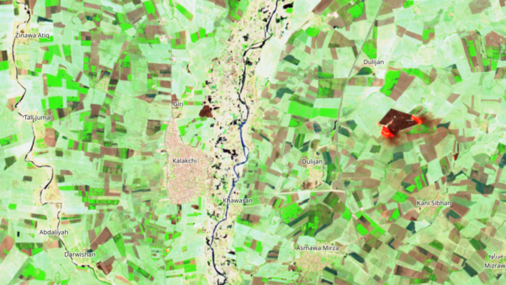
MODIS active fire detects one or more fires or other thermal anomalies (such as volcanoes) by Terra and Aqua during their overpass time. It has the ability to detect fire occurrence within 1 km. Even multiple fires could happen at the same time within the pixel, the detection is shown at the center of the pixel, which is not necessarily the “actual” location of the fire (Figure 1). The data is provided from 2001 to current, but the mission will end in late 2026/2027.
Figure 1. The illustration of MODIS Active fire detection (NASA)
Pros and cons: MODIS active fire contains information like detected date, time, confidence level, fire type, and fire radiative power (FRP) for you to assess the intensity of fire, and it provides data from 2001 to current. The global data is in near-real time, so you can assess the data within 3 hours of satellite observation, and for US and Canada, some AF products are available in real-time. However, the resolution is coarse (1km), so smaller fires are undetectable. Furthermore, the accuracy varies across region, where the minimum detection rate in the Middle East is 7%, and the maximum rate is 26% in Australia and New Zealand (Giglo, 2016).
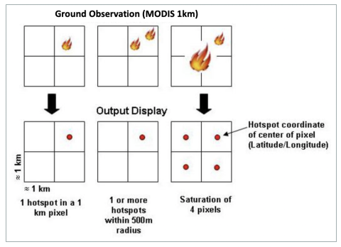
As with MODIS AF, VIIRS’s sensors- NOAA-20 (available since April 2018), NOAA-21 (available since January 2024) and S-NPP (available since January 2012), are also polar-orbiting satellites. Owing to its finer spatial resolution (750m and 375 m), and MODIS AF-derived contextual thermal anomaly algorithm, it is optimized to detect small, fragmented, and low intensity fires compared to MODIS AF. Note that the confidence value for VIIRS are determined by three levels- low, nominal, and high, which are associated with fire pixels and sun glint effect. Low confidence level pixels are associated with areas of sun glint and lower temperature anomaly, while high confidence pixels are associated with day or night-time saturated fire pixels.
Figure 2 Comparison between MODIS, VIIRS (SNPP and NOAA20) active fire data showing fire events in Syria in June 2019. For MODIS, the confidence level threshold is 80, and “high” for VIIRS.
Geostationary active fire
Geostationary active fire data addresses the gap of the overpass frequency by fixing the observation point. Positioned at an altitude approximately 45 to 50 times higher than MODIS or VIIRS, these sensors are operated by four major meteorological agencies: NOAA (GOES-16/18), EUMETSAT (Meteosat 9/11), and JAXA (Himawari-8). While these platforms provide high-frequency observations at 10–15 minute intervals, they possess a much coarser spatial resolution (2 km to 3 km), which complicates the detection of smaller fires. Currently, Geostationary data is only available in FIRMS provided from August 2022 to present, but due to the commission and omission error, the data has been filtered for better accuracy. However, as the writer tried in January 2026, the geostationary active fire data is only available through the map view, without direct data access.
There are also real-time (RT) and ultra real-time (URT) active fire available, but it only covers four areas centred with ground stations, which can be found here. The RT and URT active fire data are processed directly using the raw satellite data, where RT data is available 30-60 minutes over satellite overpass and URT can achieve it within 1 minute.
Feature
Geostationary (GEO)
MODIS (Aqua/Terra)
VIIRS (S-NPP/NOAA-20)
Orbit Type
Geostationary (Fixed)
Polar (Moving)
Polar (Moving)
Altitude
~35,800 km
~700 km
~820 km
Detection Frequency
Every 10–15 minutes
~2 times per day Terra: approx. at 10:30 AM/PM Aqua: approx. at 1:30 PM/AM
~2–4 times per day NOAA-20/21: approx. at 12:40 AM S-NPP: approx. at 1:30 AM
Pixel Size (Detail)
Coarse (2 km – 3 km)
Moderate (1 km)
Fine (375 m)
Best For
Tracking fire growth/spread in real-time.
Long-term fire trends.
Mapping precise fire perimeters.
Table1. Comparison between different active fire data
What is burned area?
Burned area products are designed for providing not only where the fire happened, but also the area burned, which can be referred to as a ‘burned scar’. While active fire products detect thermal anomalies (heat) at a specific moment, burned area products map the area with sudden vegetation changes due to fire in the landscape, demonstrating the spread of the fire.
MODIS burned area
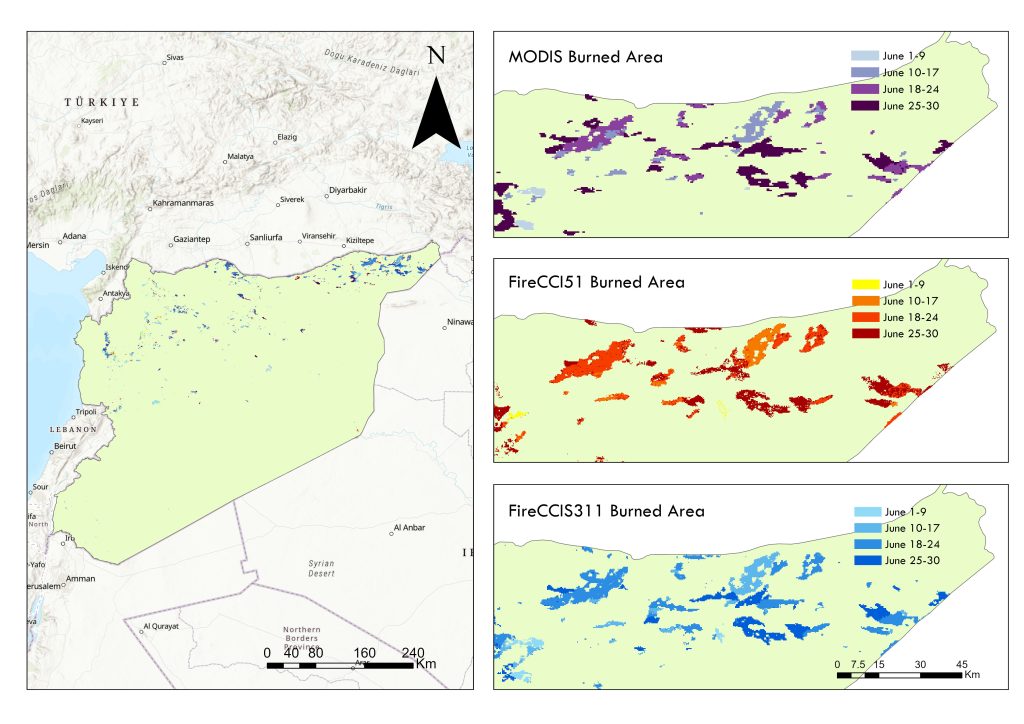
Aligned with MODIS AF data, MODIS BA (MCD64A1) collection 6.1 used 500m MODIS imagery and MODIS 1km active fire data, coupled with burned sensitive vegetation index from MODIS short-waved infrared band 5 and 7 to identify burned area. The data layers include burn data (1-366), burn date uncertainty (0-100) and quality mask. The data is available from 2001 to present. You can also download the data using Google Earth Engine.
Fire Disturbance Climate Change Initiative (FireCCI) Burned area products is a series of burned area dataset developed by European Space Agency (ESA)using MODIS AF and daily reflectance. Below, we introduce all the CCI datasets.
FireCCI51(v5.1)
This is currently one of the most widely used global fire datasets. It is based on MODIS 250m resolution imagery and MODIS active fire, and it covers the period from 2001 to 2020. Compared to MCD64A1, FireCCI includes confidence level layer and land cover layer from CCI Land cover (LC_cci v2.0.7). It is important to know that this land cover product only includes data from 1982 to 2015, so the land cover information for FireCCI51 is using data from 2015 for the year of 2017 to 2020. You can also download this data on Google Earth Engine.
It uses AVHRR satellite data to provide the longest available global fire history, covering from 1982 to 2018. It is developed to cover historical fire patterns. However, the spatial resolution for pixel data is 0.05° (~5 km), which is relatively coarse compared to most of the BA products.
FireCCIS311 product is a recent global burned area using short and long short infrared from Sentinel-3A/3B SYN and VIIRS active fires data, coupled with global land cover data from C3S LC version2.1.1, this dataset offers a spatial resolution of 300 meters from 2019 to 2024. As this data is not available on Google Earth Engine, I downloaded the pixel-based geotiff files from the Open Data Portal at ESA Climate Office’s website.
Figure 3. Visualization of three different burned area datasets (MODIS BA, FireCCI51 BA, and FireCCIS311 BA) of June 2019 in Syria. The BA patterns are generally similar, but FireCCIS311 captures more smaller fires compared to the other two datasets.
Copernicus burned area
Built on MODIS Burned area and FireCCI burned area products, Copernicus burned area have launched a series near real time burned global burned area datasets with s special resolution of 300m, becoming the first mission to achieve this goal. Its daily global burned area products even make the data available within 24 hours after satellite overpass. The following four latest BA data are available to visualize on Copernicus EO blower. However, if you want to download the data, you might need to check out the instruction here for more information. This is the way I do: create a credential to get the access key and secret key, and I used Python to download the geotiff files.
Burned Area v3.1- CGLBA31ntc (Monthly, 2019-2025)
CGLBA31ntc and CGLBA31nrt are recent products using Sentinel-3 A and B satellites and VIIRS active fire data, with deep learning model for burned area prediction, providing 300m burned area. NTC refers to “non-time critical”, with improved accuracies but a few weeks after the data acquisition. This dataset is therefore in monthly temporal frequency. However, based on the validation in 2019 and 2020, the accuracy of this dataset shows lower accuracies compared to FireCCIS311, with large commission errors over limited regions. Also, it is important to know that the model does not take dissipation of ask and char and vegetation regrowth, which might lead to underestimation of burned area.
Burned Area v3.1 -CGLBA31nrt (Daily, Near Real-Time, 2023-2025)
Followed by CGLBA31ntc, the advantage of CGLBA31nrt is that it provides daily burned area, which is useful if you want high temporal resolution burned area data.
Burned Area v4.1 – CLMBA40ntc(Monthly, 2018-present)
Compared to the version 3, the difference is that version improves the accuracy, and provides more data layers including classification probability, burned fraction, and large fraction probability.
Burned Area v4.1 – CLMBA40nrt (Daily, Near Real-Time, 2025-present)
As similar to CGLBA31ntc , the CLMBA40nrt is the version 4 of 300m daily burned area.
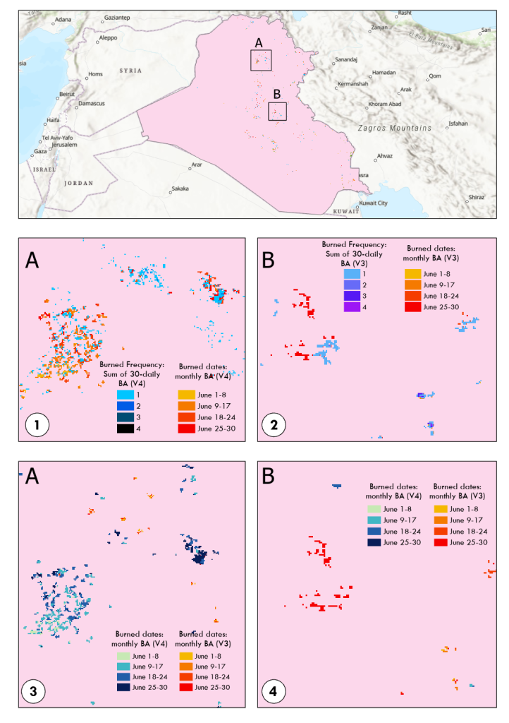
Here I want to show a map of burned area in Iraq in June, 2025, using the above four Copernicus burned area products, showing the different between different versions and different temporal resolution. I didn’t choose Syria this time because there was barely fire in June 2025 in Syria, which is also another topic to look at.
As shown at figure 3, we can see the comparison between four Copernicus BA datasets. To make the daily BA and monthly BA comparable, I summed up the 30 daily BA to calculate the burned frequency in a month using GIS. Between map 1 and 2, I compared the difference between daily and monthly products for version 4 and version 3 at subarea A and B. You can see that:
30-daily-sum BA data detect some small fires that monthly BA did not detect.
Several pixels have been burned 2-4 times, showing that monthly BA missed some multiple-burned fires
Between map 3 and 4, we compare the difference between version 3 and 4 using only the monthly BA at subarea A and B, and you can see that some fires are detectable via version 3 but not version 4, and vice versa. When looking at the same month in this area, we notice that version 4 show more fire than version 3. Nevertheless, these two fire products generally show similar spatial pattern in June 2025, Iraq.
Figure 4. The comparison between four different Copernicus burned area products
Fire Atlas
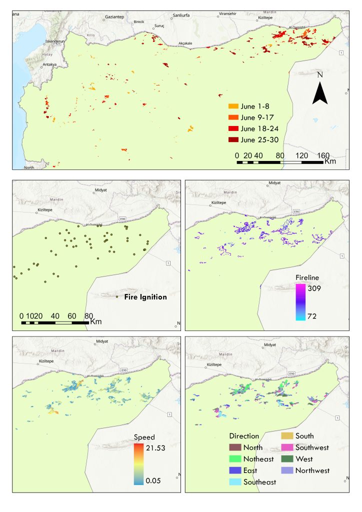
Based on 500m resolution MODIS burned area products, the Global Fire Atlas dataset addressed the gaps in distinguishing fire pixels with multiple ignition points. It traces individual fires’ timing, location of ignitions, fire size, duration, daily expansion, fire line length, speed, and direction of spread, providing individual fire behavior with both raster and vector data. This is what we can use from the Fire Atlas dataset. The data is provided from July 2003 to February 2025, with both monthly and yearly geotiff file, and annual shapefile. However, the monthly data is in 0.25-degree grid cell, and this data does not consider fire activities that happen two times a year.
The dataset includes the following files:
File name/variable
description
Day of burn
The estimated burned day, ranging from 1 to 366
Fire speed
Km/day, the speed of the fire
Fire direction
Fire spread direction. 1: north, 2: northeast, 3: east, 4:southeast, 5: south, 6: southwest, 7: west, and 8: northwest
Fireline
Average length of daily fire line (km)
Fire ignition
Point file with ignition coordinate, ignition date, extinction day of year, duration, fire line, expansion, speed, direction, and land cover (derived from MCD12Q1 Col. 5.1)
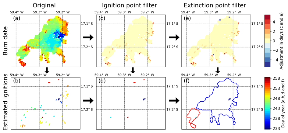
Figure 5. illustrates the algorithm used to account for uncertainty in the “day of burn” and to identify individual fires within large clusters of adjacent burned pixels, adapted from Andela et al. (2019).Figure 6. Different layers of Fire Atlas data for vegetation fire in Northeastern Syria in June 2019
30m Global Annual Burned Area Maps (GABAM)
Landsat is not often used to developed a global fire dataset due to its limited temporal resolution, and effect from clouds, while it is more common for burned area validation. The above-mention data use Landsat or Sentinel-2 data as a validating data, but Landsat-based dataset was not developed until 2021. The Global Annual Burned Area Maps (GABAM) dataset provide a higher resolution data with 30m, and it spans from 1985 to 2021. However, the limitation of detecting cropland fires still exist, and only annual burned area data is available.
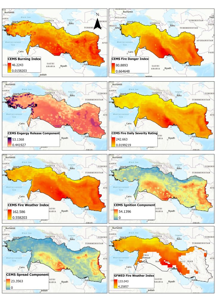
Apart from fire datasets, to assess fire risk, you can also use fire index data for fire risk prediction. The most widely used one is the Canadian Forest Fire Weather Index (FWI) System, which consists of 3 moisture codes and 3 fire behavior indices that consider both fuel moisture, availability, and weather conditions for fire risk assessment. There are also two newly developed global datasets that combine meteorological and vegetation data to evaluate fire risks, which are CEMS Fire Danger Indicies and Global Fire WEather Database (GFWED), and they are both accessible via Google Earth Engine.
CEMS Fire Danger Indices
This datasets is developed from the European Centre for Medium-Range Weather Forecasts (ECMWF), using simulated weather data from ERA5 reanalysis. These datasets are available from 1940 to present, with daily, 0.25 degree (25km) spatial resolution, consists of the following 14 components.
Measures moisture in surface litter and small twigs (<1cm). Highly reactive to hourly weather; scale 0–99.
Duff Moisture Code (DMC)
Measures moisture in loosely compacted organic layers (5–10cm deep). Affected by rain and temperature, not wind; 12-day timelag.
Drought Code (DC)
Indicates moisture in deep, compact organic layers (10–20cm deep). Very slow-reacting with a 52-day timelag; max value ~800.
Keetch-Byram Drought Index (KBDI)
Measures net moisture deficiency in deep duff and upper soil. Scale 0 (saturated) to 200 (max drought).
Build-up Index (BUI)
A weighted mix of DMC and DC representing total fuel available for combustion. Used primarily for pre-suppression planning.
Drought Factor
A value (0–10) representing how recent rain and temperature affect fuel availability. Often based on the KBDI.
Energy Release Component (ERC)
A cumulative index of available energy (BTUs) per square foot. Reflects drought conditions by tracking moisture in all live and dead fuels.
Initial Fire Spread Index (ISI)
Combines FFMC and wind speed to estimate the rate of fire spread.
Spread Component
Numerically predicts the headfire speed in feet-per-minute (though treated as dimensionless). Open-ended scale.
Ignition Component
The probability (0–100%) that a firebrand will start a fire requiring suppression action.
Burning Index
Measures the difficulty of controlling a fire by combining spread and energy release. Closely related to flame length.
Fire Weather Index (FWI)
Combines ISI and BUI to rate potential frontal fire intensity. Used for general public fire danger warnings.
Fire Danger Index
A broad metric for the probability of ignition, spread rate, and suppression difficulty. Values over 50 are typically “Extreme.”
Fire Daily Severity Rating
An exponential transformation of the FWI that reflects the actual physical effort required for fire suppression.
Global Fire WEather Database (GFWED)
This databased is developed by NASA, and it is based on the FWI system, but calibrate with weather station data from different countries, providing 0.5-0.65 degree (~50km) daily data from 1980 to present.
Figure 7. This figure demonstrates 7 layers from CMES data and 1 layer from GFWED data for the study area (Turkey, Syria, Iraq, Iran, Lebanon, Israel, and Palestine) using daily aggregated data for June 2025.
Other fire related data?
Apart from fire datasets, fire index datasets, there are also many other relevant datasets to assess fire regime based on your interest. The following datasets might provide you more information on the effect of fire.
1. Fire emission data: Fire emission data quantify the chemical species and mass of pollutants released during combustion. They are vital for atmospheric chemistry modelling and health impact assessments.
Global Fire Emissions Database (GFED)
Global Fire Assimilation System (GFAS)
Fire INventory from NCAR (FINN)
QFED (Quick Fire Emissions Dataset)
2. Aerosol data: Aerosol datasets measure the physical particles (smoke, soot, dust) suspended in the atmosphere. They are used to track smoke plumes and assess climate forcing.
Aerosol Optical Depth (AOD)
TROPOMI (Sentinel-5P)
OMPS Aerosol Index
Lidar Vertical Profiles (CALIOP/CALIPSO)
To sum up all the fire products I mentioned, the table below summarizes all the properties of different kind of fire products, and this can help you have a better overview of them.
Data name
Data type
Time period
Temporal resolution
Spatial resolution
Satellites
MODIS AF
Point
2001-present
Near real time
1km
MODIS Aqua and Terra
VIIRS AF
point
2012- present
Near real time
375m/700m
Suomi NPP and NOAA-20
Geostationary Active Fire
Point
2000 – Present (but available on F)
Sub-hourly (10-15 min)
2-3km
GOES, Meteosat, Himawari
MODIS BA (MCD64A1)
Raster
2001-present
Daily / Monthly
500m
Terra & Aqua
FireCCI51 BA
Raster
2001-2020
Monthly
250m
MODIS Terra & Aqua
FireCCILT11
Raster
1982-2018
Monthly
0.05° (~5km)
AVHRR
FireCCIS311
Raster
2019 – 2024
Monthly
300m
Sentinel-3
CGLBA31ntc
Raster
2019-2025
Monthly (NTC*)
300m
Sentinel-3
CGLBA31nrt
Raster
2023-2025
Daily (NRT*)
300m
Sentinel-3
CLMBA40ntc
Raster
2018-present
Monthly (NTC*)
300m
Sentinel-3
CLMBA40nrt
Raster
2015-present
Daily (NRT*)
300m
Sentinel-3
Fire Atlas
Raster/point
2003-2025
Daily
500m
MODIS
GABAM
Raster
1985-2021
Annual
30m
Landsat 7&8
CEMS Indices
Raster
1940 – Present
Daily
0.25°
ERA5 (Reanalysis)
GFWED Indices
Raster
1980-present
Daily
0.5°
MERRA-2 (NASA)
At this post, I tried to list out most of the global available fire datasets that are commonly used. Choosing a fire dataset is primarily determined by where you want to study? When you want to study? What is the spatial and temporal scope? What kind of data do you want? This post unfortunately hasn’t yet provided a comprehensive information about the validation of the datasets, as it varies across different regions. Features such as sun exposure, longitude, vegetation types will affect the performance of fire detection. Nevertheless, I hope this post can help you to choose the fire datasets you want.
Within the physical geography and earth observation communities, land-cover mapping is widely recognized as a foundation for understanding ecosystem function, environmental stability, and human–environment interactions. High-quality land-cover information helps us understand the land and water management, environmental risk, biodiversity health and prepare conservation strategies and is increasingly used to track progress toward the Sustainable Development Goals. In conflict-affected and data-deficient regions, where field access is limited or impossible, satellite-based land-cover mapping becomes even more critical for assessing environmental degradation, displacement impacts, and long-term recovery options (Saah et al., 2019).
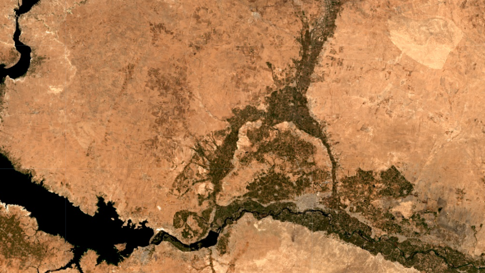
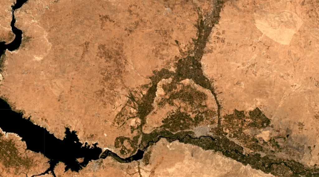
Satellite image (Sentinel-2) showing the city of Raqqa and part of Lake Assad (left), with densely packed agricultural fields (in green) on both sides of the Euphrates River.
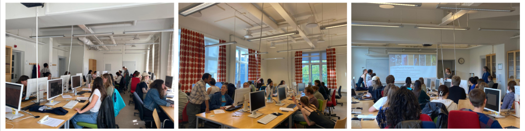
With this background in mind, the Landscape Detectives team organized the Syria Land Cover Mapathon on 7 May 2025, focusing on Syria as a conflict-affected, data-scarce landscape. The event invited participants from Lund University (Bachelor and Master Students) to look beyond single time imagery and instead interpret land cover through both historical and recent satellite data, tracing how agricultural fields have gone fallow over time, how open landscapes have been fragmented by oil extraction ponds, and how forests have been cleared and converted into other land uses. Using open-source tools such as QGIS and Google Earth Pro, volunteers acted as citizen scientists, turned raw satellite imagery into actionable, open training data that can support future research work on Syria’s landscapes.
Participants during the Mapathon event (Photos taken by Wan Ni Lin).
What makes this Mapathon particularly innovative is its focus on land-cover classes that explicitly capture the socio-political effects of conflict. Rather than relying on generic global categories, the team worked with tailored classes such as “Refugee Camp Areas” and “Abandoned Farmland,” which are rarely represented in standard global products. These more nuanced classes help illuminate not only where landscapes have changed, but also point toward why they have changed, creating an empirical entry point to study the links between armed conflict, displacement, and ecological degradation.
The target of the mapathon was to map the entire Syria in 14 different landcover classes and the participants have managed to label approximately 1600 data points which will serve as an immensely important training and validation dataset for the community of people trying to understand the Syrian landcover.
The work of this Mapathon is not an isolated initiative, but forms a core building block within the broader ECO-Syria project at Lund University: Exploring Conflict–Environment Interactions for Sustainable Development and Conservation. ECO-Syria emphasizes the intertwined nature of ecological health, social justice, and democratic governance, and highlights how information gaps about land-cover change can undermine both environmental management and peacebuilding efforts.
By generating precise, high-resolution land-cover data for a region where ground-based surveys are constrained by insecurity, the Mapathon directly addresses this information gap. The training data produced through the event has already supported the development of a publicly accessible 10 m resolution land-cover map for Syria under the ECO-Syria umbrella, providing an empirical foundation for analyzing ecosystem condition, land degradation, and livelihood pressures across the country. The scientific outputs linked to this work, including detailed documentation and methodological articles, will be shared in due course, and the full training dataset will be openly available on Zenodo so that others can build upon, test, and refine land-cover models for Syria and beyond. You can reach us by contacting Lina Eklund and Purnendu Sardar for any queries.
In September 2025, the Critical Physical Geography group at Lund University organized a 1.5 day workshop on extractivist and anti-extractivist research, funded by the Strategic Research Area Biodiversity and Ecosystems in a Changing Climate (BECC). The workshop included presentations on the theme, followed by discussions about how to reduce the extractivist elements in social-ecological research. Below is a summary of the discussions and reflections that took place during the workshop.
What is extractivist research?
The term “extractivism” commonly refers to the extraction of natural resources where valuable resources are mined, followed by the extractors moving on to the next location with no care or interest in what happens to the local community or environment post-extraction. This dynamic has increasingly been highlighted as an issue also in academic research, known also as parachute, helicopter, parasitic, or neo-colonial research.
The topic has primarily been used in the context of researchers from the Global North studying and extracting data from on the Global South, but the dynamic is not limited to the international scale; researchers have also pointed out the harms caused by ‘domestic helicopter research’. In both cases, it is an issue of the power dynamics involved in how knowledge is created and exchanged, and who benefits from the research.
Discourses around the power dynamics between the researcher and the researched have existed for several decades. An early work is Linda Tuhiwai Smith’s 1999 book Decolonising Methodologies. It has since expanded from indigenous and decolonial studies into fields such as global health, anthropology, and geosciences.
The terminology used to describe these dynamics has also changed and expanded (scholars have traced the definition and scope of extracitivism). Both the term extractive and extractivist are sometimes used. We understand the former as a narrower term relating to the act of taking something of value from a location or community, and the latter as a broader description of the system that relies on extraction to maintain an uneven distribution of knowledge, wealth, and power.
Is it possible to avoid extraction/extractivist activities in field research?
Within the geography discipline(s), and many similar disciplines, doing field research is a way to get closer to the study area, to better understand the processes going on, and to collect data to be used in research. When discussing helicopter, parachute, or extractivist research, it’s easy to get the feeling that we should just avoid doing fieldwork altogether, at least in locations far from our own backyards. During the workshop we discussed the importance of doing field work as part of research that benefits the researched communities, and whether and how we can avoid extractivist research.
“External researchers”, can document things that may not always be possible for local communities to document. In authoritarian contexts, for example, not all types of research or results may be safe to carry out, especially for local researchers. This also means that co-authoring with local researchers may not be possible, or when we do, we need to be careful how we frame our work to ensure that our publications will not put anyone in danger. Through our platform, as researchers, we can also help make communities visible. Some workshop participants had witnessed appreciation from local communities about researchers being there, ensuring their voices are heard.
There will almost always be extractive elements in field research, but these extractive elements can be countered by activities that seek to benefit the communities in the study area, through for example co-designing of research projects with stakeholders, training workshops, or translation of research results to local languages. The term anti-extractivist does therefore not fully reflect the general conclusion of the workshop, as it implies that we need to oppose extractivism at all times. Instead we suggest using the term “counter-extractivist research practices”, and acknowledge that the fear of being extractivist may hinder important research, and suggest that we balance the negative with positive actions.
How to conduct counter-extractivist research?
Below we listed some points for researchers and funding institutions to reflect on:
For researchers
Reciprocity
Reciprocity indicates co-benefit between researchers and local communities, reframing research as a collaborative, mutually beneficial process, rather than one-sided data collection. At the workshop, we discussed the following reciprocity methods for counter-extractivist research.
1. Capacity Building
In many contexts, one of the most meaningful ways researchers can contribute to local communities is through capacity building. This involves training community members in research design, data collection, or relevant technical skills, while being mindful of participants’ schedules, needs, and availability. For long term impact, capacity building should not end right after researchers leave the field, instead, it can provide sustainable support such as follow-up activities or even long term network building, ensuring that communities retain agency and benefit from the skills and knowledge developed during the research process.
2. Data Sharing and Co-creation
Research data often holds significant value for the communities from which it is derived, yet it frequently remains inaccessible to them. Therefore, researchers should make the data accessible for people who have contributed the data and negotiate co-authorship or other formal recognition for local communities’ contributions. However, as mentioned, researchers should also be sensitive to any potential harm for local communities in terms of the information they are sharing, prioritizing the safety of the contributors.
3. Translation and Research Communication
Research findings are of limited value to local communities if they cannot access or understand them. Researchers should therefore commit to translating research outputs and key findings into local languages. It can also be an option for researchers together with local communities, hold accessible workshops or open meetings, or provide policy briefs or recommendations, making the research impact beyond academia.
4. Monetary and Non-monetary Compensations
Whether research participants should be compensated for their engagement was discussed at our workshop, where some thought it was a good way to benefit the subjects while others were concerned about how that affected the relationship between researchers and research participants. This is a difficult question that is context-dependent and requires balancing different aspects. In some cases, vouchers, skill development opportunities, or support for local projects may be more appropriate than direct monetary payment, particularly where such payment is contested or could create unintended consequences. Compensation may be discussed openly at the beginning of the research project to ensure transparency and aligning expectations among researchers and the communities.
5. Ethical Reflexivity & Power Dynamics
Counter-extractivist research involves ongoing ethical reflexivity. This includes researchers articulating their positionality and consider the potential impacts of their presence and activities on community dynamics. The practice of reflexivity is not common in all disciplines. In natural sciences it may be seen as a subjective to include a reflexivity statement in publication, however, some argue for more reflexivity in the natural sciences. Reflexivity should not be a one-time exercise but and ongoing proccess throughout the research cycle, including project proposal, research conduct, publication and communication.
For institutions and funding agencies
Flexible Research Policies with inclusion of reciprocity
Although there were no participants from funding agencies or administrative offices at our workshop, we still want to advocate the importance of counter-extractivist research in all aspects of the research cycle. Institutions and funding agencies can enable counter-extractivist research by adapting their policies to reflect the realities of co-created, iterative research. For funding agencies, it is important to embed reciprocity into the financial structure of research projects, such as providing dedicated funds for translation, workshops, community events, and/or local engagement activities, recognizing that meaningful relationships and community benefit cannot be built within the constraints of short-term projects. Finally, policies should encourage flexible, context-specific approaches to compensation and community benefit.
Evaluation and Impact Criteria
Traditional evaluation criteria for e.g. research projects and promotion tend to privilege academic outputs such as publications and citations, often overlooking the broader social and ethical dimensions of research. Institutions and funding agencies should move this evaluation model towards evaluating research impact holistically, considering capacity-building, community benefit, and ethical conduct alongside conventional metrics. This shift also requires creating space for critical reflection, allowing researchers to report negative or unintended impacts and propose remedial actions without penalty. Such transparency fosters a culture of learning and accountability, ultimately strengthening the integrity and relevance of research practice.
Balancing influence of local participants with research integrity
Conducting research often involves a delicate balancing act between local participants’ perspectives and academic rigor. During our workshop, we identified two questions: First, what are the local communities’ perspectives and how do we include local communities’ perspectives ethically? This involved determining whose voices are representative, how many individuals are needed to capture the necessary breadth of views, and what protocols should guide the researcher when the opinions within the community or across different communities do not align.
Secondly, how should researchers proceed if community opinions diverge from the research objectives, or if conflicts within the community arise? It is a difficult question to navigate, as research goals might not necessarily meet communities’ expectations. We concluded that maintaining an open mindset is crucial, especially upon first entering the study area. This flexibility allows us to navigate communities’ input rather than imposing rigid assumptions. Furthermore, it is important to evaluate the potential impacts and tangible consequences that research findings will have on the involved communities, and consider the communities’ needs. We think this could help build trust between researchers and the community and avoid potential conflicts while maintaining research integrity.
The role of the overall system
The responsibility of avoid extractivist research practices should not be placed solely on individual researchers. The overall system in which we work, with the publish-or-perish mentality, the short research projects, and the high workloads makes counter-extractivist research difficult. A first step is to start talking about the need for counter-extractivist research and ensure that anyone carrying out fieldwork understands that their research activities might impact local communities in different ways, and that there are ways to counter these dynamics. Awareness about the problems of extractivist research could enable changes to the overall system. For example, funders being explicit about the ability to include reciprocity related activities in the budgets of research projects would likely encourage such activties. The so common three-year research project is also an obstacle to counter-extractivist research, as there simply is not enough time for e.g. establishing trust, co-creation of research design, and reciprocity activities.
Conclusion
This workshop brought together PIs, PhD students, and master’s students from different disciplinary backgrounds, reflecting on the challenges and possibilities of conducting ethical, reciprocal field research in social-ecological contexts. A central insight was to acknowledge the process of knowledge production and recognize the extractive elements in field research. Rather than using the workshop name “anti-extractivist research” , we propose the term “conter-extractivist research practices” to acknowledge the extractive dimensions of research while actively working to balance them through meaningful reciprocity, capacity building, and genuine partnership with local communities.
Our discussions emphasize that counter-extractivist research is not solely the responsibility of individual researchers. While researchers must cultivate reflexivity, prioritize community benefit, and navigate power dynamics with care, lasting change requires transformation at the institutional and systemic levels. Universities, ethic boards, and funding agencies must understand the importance of conducting counter-extractvist research practices, by supporting researchers : longer project timelines, flexible ethics frameworks, explicit budget lines for reciprocity activities, and evaluation criteria that value community impact alongside academic outputs.
We also recognized the importance of maintaining research integrity while remaining open to community perspectives—a balance that requires humility, flexibility, and ongoing dialogue. Researchers entering the field must be prepared to adapt their approaches in response to local contexts, needs, and feedback, while remaining attentive to the tangible consequences their work may have on the communities involved.
At the end, we beleive that counter-extractivist research is not a fixed destination but a continuous process of reflection, negotiation, and improvement. By raising awareness of these dynamics, fostering institutional support, and including reciprocity into the fabric of research practice, we can move toward a model of knowledge production that is more equitable.
In 2019, Syria and Iraq saw a spike in vegetation fires, a pattern not seen in neighbouring countries during the same year. During this year 4.8% of Syria’s total land area burned. This is not only a spatial anomaly (compared to neighbouring regions with similar climates), but also a temporal anomaly, as it is a 2300% increase relative to the average fire activity in Syria (Zubkova, 2021). Wan Ni Lin also found that 3.5%, compared to the average <1%, of Iraq’s total land area burned during this year (paper to come).
Global fire data, such as the MODIS Thermal Anomalies and MODIS Burned Area products, are coarse and can miss important details on the pattern and behaviour of fires. For areas like Australia, North America, and Europe, high-resolution data specifically produced for the respective region exists (see CSIRO, NASA, and Copernicus), but this is not the case for many other areas around the globe. For a conflict-stricken, arid and understudied region with limited data availability, like large areas of the Middle East, this gives rise to both scientific opportunities and challenges.
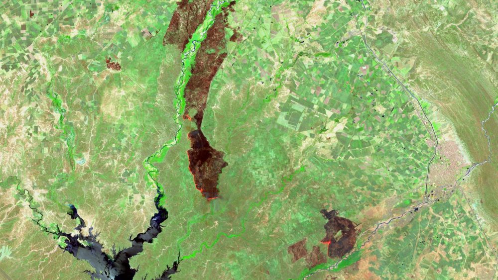
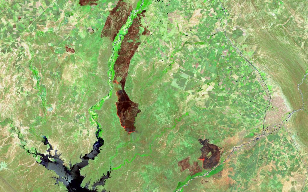
In late 2025, we organized a mapathon focusing on this issue, aiming to map active fires and burn scars in a 1 000km² (100 000ha) area covering parts of Syria, Iraq and Turkey. This is our second mapathon, made possible with the help of SWECO, as we used their workspace (and WiFi) in Malmö, and SamGIS, who graciously paid for our pizzas. The participants of the event managed to classify approx. 40 active fires and nearly 500 burn scars using Sentinel-2 imagery – something we definitely consider a success. Examples of what an image used in the mapathon can look like, can be seen below.
Sentinel-2 image of an active fire (bright orange) and burn scars (brown) in a vegetated area in Iraq during the summer of 2019. Agricultural fields can be seen throughout the image, while a waterbody is present in the lower, left corner.
The collected data will contribute to a more efficient way for us to map fire regimes, hotspots (areas with high frequency or intensity of fires) and anomalies in the entire Middle East. The collected data will be the basis of mapping these fires and scars using a machine learning approach, which in turn can help us understand how spatiotemporal patterns of vegetation fires relate to geopolitical contexts (e.g. armed conflict).
The event is also significant as it contributes both to freely available data on a pressing topic and a data-limited region, and as it introduces remote sensing (satellite imagery) and geospatial-focused methods to a greater group of people. Geographers or geo-specialist which have previously not worked with fires, the Middle East, or neither. We are grateful for the contributions and happy that so many want to contribute to important research!
Pictures from the event, taken by Wan Ni Lin (left & right), and Lovisa Rosenquist Ohlsson (middle).
“Not everything that can be counted counts. Not everything that counts can be counted.”
-William Bruce Cameron, 1963
The quote above is sometimes attributed to Albert Einstein, but it was actually from a book about sociology, published in 1963. The context is a discussion about how nice it would be if sociological data was just numbers that could be put into ”IBM machines” (nowadays called computers), but then the author wanted to highlight that not everything can be analyzed quantitatively, some knowledge comes from more qualitative approaches. In Physical Geography, the emphasis is often on “counting” to reach conclusions, but as we move towards more and more complex questions about the Earth and its system, we need to start engaging with other forms of data and approaches to knowledge acquisition.
Geography is a discipline with immense potential for interdisciplinarity, yet, the discipline have for a long time been divided into human geography and physical geography, with limited communication between the two. Being “interdisciplinary” in a disciplinary system can be challenging. You are supposed to be an expert in one discipline, and at the same time be able to communicate and understand other disciplinary approaches, and because of that you are often outside of your scholarly comfort zone.
Critical physical geography, as defined by Rebecca Lave and colleagues (see reading list below) is an attempt to move towards bridging the gap between physical and human geography, and towards acknowledging the role of power dynamics in how landscapes are shaped. It has it’s basis in physical geography, still interested in physical geography questions, but with a good understanding of the socio-economic and political dimensions that cannot be disregarded when seeking to answer such questions. Humans are seen as more than just a disturbance.
As critical physical geographers at Lund University, we
are aware of the existence of different types of knowledge production (epistemologies), and are open towards other ways of producing knowledge than “our own”
are interested in combining physical science with social science for a deeper understanding
question science as an objective process and discuss science as a subjective process that is influenced by the positionality of the person conducting the research
propose that the above mentioned subjectivity is not necessarily a problem as long as there is transparency about what assumptions and decisions were made when doing the research, and how they might influence the result
acknowledge that the answers we find are shaped by the questions we ask and the definitions we use
place people, power dynamics, and politics at the center of physical geography
are interested in the critical aspects of physical geography, GIS and Remote Sensing
highlight and discuss questions of ethics in the scientific process
Lave, R., Wilson, M. W., Barron, E. S., Biermann, C., Carey, M. A., Duvall, C. S., Johnson, L., Lane, K. M., McClintock, N., Munroe, D., Pain, R., Proctor, J., Rhoads, B. L., Robertson, M. M., Rossi, J., Sayre, N. F., Simon, G., Tadaki, M., & Van Dyke, C. (2014). Intervention: Critical physical geography. Canadian Geographies / Géographies Canadiennes, 58(1), 1–10. https://doi.org/10.1111/cag.12061
Critical Remote Sensing
Bennett, M. M., Chen, J. K., Alvarez Leon, L. F., & Gleason, C. J. (2022). The politics of pixels: A review and agenda for critical remote sensing. Progress in Human Geography, 46(3), 729–752. https://doi.org/10.1177/030913252210746
Bennett, M. M., Gleason, C. J., Tellman, B., Alvarez Leon, L. F., Friedrich, H. K., Ovienmhada, U., & Mathews, A. J. (2024). Bringing satellites down to Earth: Six steps to more ethical remote sensing. Global Environmental Change Advances, 2, 100003. https://doi.org/10.1016/j.gecadv.2023.100003
Feminist perspectives/critiques
Haraway, D. (1988). Situated Knowledges: The Science Question in Feminism and the Privilege of Partial Perspective. Feminist Studies, 14(3), 575–599. https://doi.org/10.2307/3178066
Kroth, L. (2025). Remote sensing and feminist critique: Reappropriations of sensing across distance. Environment and Planning F, 4(1), 3–19. https://doi.org/10.1177/26349825241283838
Litfin, K. T. (1997). The gendered eye in the sky: A feminist perspective on earth observation satellites. Frontiers: A Journal of Women Studies, 18(2), 26–47.
Schuurman, N. (2002). Women and technology in geography: A cyborg manifesto for GIS.(Focus: Equity for women in geography). The Canadian Geographer, 46(3), 258–266.
Rula Graw wrote her bachelors thesis during the spring of 2025 as part of the Critical Physical Geography working group. Here is her abstract:
This research studies vegetation dynamics in the West Bank under ongoing occupation using Sentinel-2 satellite imagery and the Normalized Difference Vegetation Index (NDVI). Using annual NDVI composites from 2017 to 2024, the NDVI change across Area A, B and C, areas with different control established during the Oslo agreements, were studied. The results show broadly uniform NDVI patterns across these zones, aside from a lower NDVI in 2017 attributable to drought. To isolate anthropogenic drivers of vegetation loss during the years 2018 – 2024, three case studies have been conducted: the settlements of Ariel (1) and Ibei Hanachal (2), and a segment of Road 60 (3). By combining NDVI-change rasters with true‐color (RGB) composites of Sentinel-2, localized decreases in vegetation were analyzed in relation to the horizontal expansion of Israeli settlements and road infrastructure. Impacts of anthropogenic expansion on the natural environment in the West Bank include destruction of productive agricultural land, contamination of downstream water resources by untreated wastewater, and the road expansions impacting the wildlife in the region.
While wide reaching NDVI patterns remain stable, large‐scale analyses reveal meaningful “green-to-grey” transitions driven by settlement expansions and road constructions. The study highlights the utility of remote sensing for conflict‐zone monitoring, while also noting limitations in detecting vertical urban expansion and species‐level vegetation change. To overcome these limitations in the future, incorporating very high resolution imagery and fieldwork can enhance the analysis. They can deepen understanding of land‐cover transformation, differentiate vegetation types and help to better understand the complex relation between spatial change, vegetation, and socio‐political processes under conditions of occupation.
Emma Alice Coppel wrote her masters thesis during the spring of 2025 as part of the Critical Physical Geography working group. Here is her abstract:
How does conflict affect forests? In Northwestern Syria, some of the country’s last Mediterranean forests are silently disappearing. These forests, mostly found in the governorates of Idlib, Tartus, Latakia and Hama, are important for climate regulation, biodiversity and livelihoods, but they’ve come under growing threat. Since the Syrian conflict began in 2011, concerns have grown about the long-term impact of conflict on these fragile landscapes. Fires are often suspected to increase during times of intensified violence, but the exact relationship between conflict, fire and tree cover remain unclear.
This study explores that relationship by analysing 20 years (2004–2023) of forest cover change in the region. It investigates how forest loss connects with armed conflict, fire outbreaks, and shifts in climate. The aim is to better understand how these pressures interact and what that reveals about the hidden environmental toll of war.
Since it’s too dangerous for scientists to work on the ground in war zones, this study used data collected from satellites. It looked at forest loss, fire outbreaks, weather changes and records of violent events over 20 years. By using data like global forest and fire maps, temperature and rainfall data and conflict event data, the study analysed where and when forests were lost and how it was related to fires and conflict events. Special mapping techniques were used to find places where fire and violence often happened together.
The results show notable forest loss across all four governorates, particularly from 2011 onwards. Latakia, Hama and Idlib emerged as key area for forest cover loss. High fire activity years, such as 2012, 2016 and 2020, aligned closely with peaks in forest loss, especially in areas experiencing active conflict, however indirect effects of the war also contributed to forest loss. Spatially, fire and conflict events revealed to have a clear overlap, where high conflict zones occurred near high fire zones, most noticeably in northern Latakia, and Idlib. Additionally, the study found strong correlations between fire events and climate anomalies, such as increased temperatures and reduced rainfall, demonstrating the climate’s role as a key enabler of fire outbreaks.
Overall, this research shows that forest loss in Syria cannot be explained by a single cause. Instead, it results from the combined pressures of armed conflict and its indirect effects, climate change, and fire. These forces feed into one another, accelerating forest loss and damaging ecosystems already under stress. By bringing together long-term environmental and conflict data, this project provides new insight into how nature is affected by war and highlights the need for future interdisciplinary research that includes social ecological and political factors.


Comments